| B. Geerts | 10/'98 |
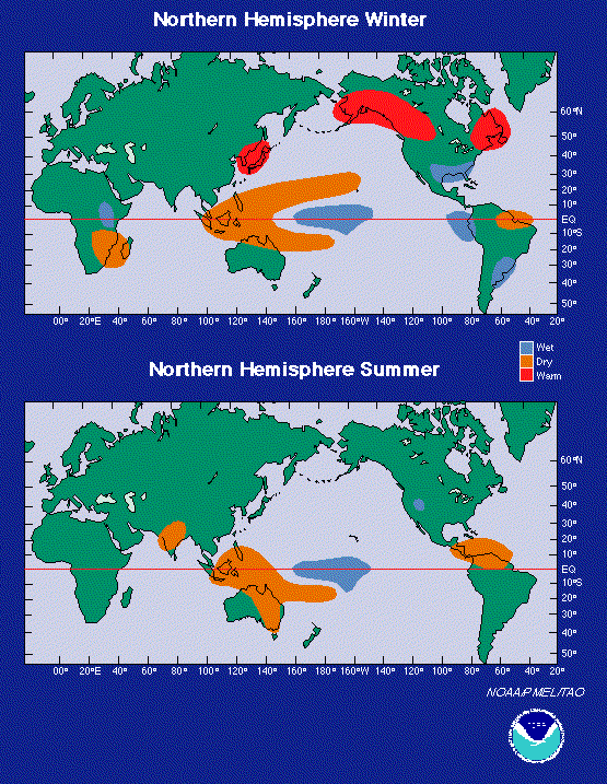
It has long been known that the El Niño/Southern Oscillation (ENSO) of the equatorial Pacific Ocean affects rainfall and temperature elsewhere in the tropics and even at higher latitudes. The very intense El Niño event of 1997-8 clearly demonstrated (1) what was suspected before, that the Indian Ocean experiences cyclical fluctuations in upper ocean temperature, and that a sudden fluctuation may be triggered by an El Niño event in the Pacific (2).
It has long been known that the sea-surface temperature anomalies describe a see-saw pattern between the centre equatorial Indian Ocean and Indonesian waters. This oscillation is known as the Indian Ocean Dipole or IOD (3). Even a strong event in the Indian Ocean is weak compared to an average El Niño, but like ENSO, the IOD periodicity is ill-defined. The most likely period was three years during 1946-79. The IOD index (based on SST variations, not pressure, as for the SOI) correlates with Australian rainfalls, especially over the western half of the continent.
The Indian and Pacific Oceans may be linked in a related pattern, with the much weaker El Niño pattern in the central Indian Ocean locked in phase to that of the Pacific Ocean. An El Niño begins in the Pacific when the thermocline dips deeper than normal in the central equatorial Pacific and the deep layer of warm surface waters subsequently is transported eastward toward the coast of the Americas. When this movement, associated with Kelvin wave propagation, reaches the coastline, it is "reflected" and moves back across the Pacific in the form of a Rossby wave that continues to affect climate and ocean circulation. Some of this wave motion may penetrate through the Indonesian archipelago, a porous boundary, and reach Africa, where it causes a deepening of the thermocline, as in Peru. This causes unusually warm water off equatorial eastern Africa, which may result in disruptive floods, as happened in Kenya, Ethiopia and Somalia in October -November 1997, i.e. after the normal end of the wet season there. Also, in late 1997 the surface wind anomalies were easterly in the central equatorial Indian Ocean, suggesting that a Walker-like circulation cell had established, with uplift over eastern Africa and subsidence over Sumatra (Indonesia), which experienced a severe drought. El Niño-like phenomena in the Indian Ocean were shorter-lived than in the Pacific.
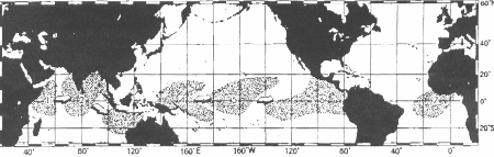
For example, when the warm water pool in the Pacific is centered at a longitude of about 160°W, the warm water pool in the Indian Ocean is beginning to be displaced eastward from about 50°E longitude of the tip of India (Figure 1). When the pool arrives during the course of a 3- to 7-year cycle along the coast of the Americas in the Pacific, the pool in the Indian Ocean is off the coast of India. During this state, droughts are seen throughout India, while flooding and its related economic and health perturbations are occurring across Central and parts of South America.
Fig 1. During a 3- to 7-year cycle, a warm pool in the Indian Ocean moves eastward (1 to 3). Meanwhile, the same phenomenon occurs in the Pacific Ocean (4 to 6). The 1 and 5 events and the 2 and 6 events are in sync. In the Atlantic, a warm pool (7) develops 12-18 months later.
However, the previous intense El Niño in 1982-83 did not trigger a mini-El Niño in the Indian Ocean, and some mini-El Niño events in the Indian Ocean occured independent of an El Niño in the Pacific.
Also, the dynamic processes within each ocean appear to be different. For starters, the warm pool propagates more slowly along the equator in the Indian Ocean that the warm pool does in the Pacific Ocean. After the full-fledged El Niño in the eastern Pacific dissipates, the warm pool in the Indian Ocean continues eastward to Indonesia and southeastward into the Timor Sea north of Australia. In addition, the circulation of the pool in the Indian Ocean appears to be linked with the 3- to 7-year perturbation in monsoon winds that blow along the coastlines of East Africa, India, and Indonesia. During an Indian Ocean El Niño, the southwesterly summer monsoon is much weaker, and less moisture is being advected over India.
There may also be links between the Pacific El Niño and the Atlantic Ocean, but this is even less understood. The warming in the Atlantic does not seem to be the result of eastward movement of warmer water pools. Instead, the ocean responds passively to atmospheric forcing: shifts in global atmospheric sea level pressure and surface winds that appear to be related to ENSO in the Indo-Pacific region. While the El Niño peaks in the eastern Pacific, southeasterly winds across the equatorial Atlantic are stronger than normal, cooling Atlantic surface waters, leading to arid conditions in Brazil's Nordeste and eastern Amazon Basin. About 12 to 18 months after the Indo-Pacific El Niño occurred, the easterly winds' relaxation is accompanied by warmer surface waters in the equatorial Atlantic (2).
References